
LAND SURVEYORS
At Foresite Geomatics Ltd we use the latest technology and survey techniques to provide our clients with a full range of high quality and cost-effective services.
Working with architects, engineers, developers, and planners, we have experience of working on projects of all sizes; building lasting, trusting relationships with our clients.
Our wealth of knowledge ensures we promptly deliver accurate data to allow our clients to plan, design and construct, while reducing the likelihood of unforeseen costs and delays; ensuring more efficient and successful projects.
SERVICES

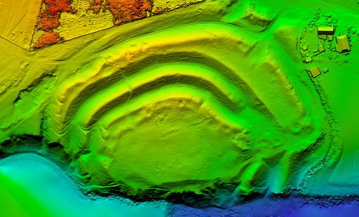
TOPOGRAPHICAL SURVEYS
Our topographical surveys deliver accurate, detailed site data to support confident planning, design, and construction. By capturing both natural and man-made features, we help reduce risk, improve efficiency, and ensure your project starts on solid ground.
> read more

MEASURED BUILDING SURVEYS
We deliver accurate, detailed records of buildings to support confident design and construction. Using laser scanning and precision measurement, our surveys give you the reliable data you need before you build, renovate, or refurbish.
> read more

DEFORMATION MONITORING
We monitor and analyse structural and ground movement over time to help detect issues early and reduce risk. Using advanced surveying technology, we provide reliable data to protect assets and ensure long-term stability.
> read more

HD LASER SCANNING
Our 3D laser scanning services deliver highly accurate point cloud data to support design, construction, and asset management. BIM-ready outputs ensure seamless integration into your workflow with exceptional precision and efficiency.
> read more

UNDERGROUND UTILITY SURVEYS
We accurately detect and map buried services using EML and GPR technology, helping reduce risk and ensure safe excavation. Our surveys deliver reliable, AutoCAD-ready utility plans referenced to national standards.
> read more

BOUNDARY SURVEYS
Our boundary surveys accurately define and map property limits, identifying markers, corners, and any encroachments. They help protect property rights, prevent disputes, and give landowners complete confidence in their boundaries.

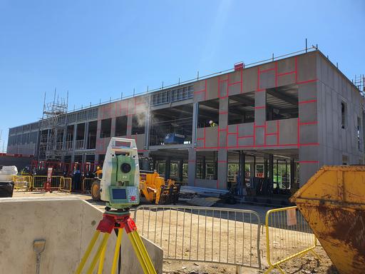
ENGINEERING SERVICES
Efficient and cost-effective solution to your site control and setting-out requirements.
SUSSEX OFFICES
Foresite Geomatics are proudly based in Burgess Hill, West Sussex.
EMAIL US
Contact us via email with your project requirements.
CALL US
Call our team on 01444 672090 to discuss your project requirements.