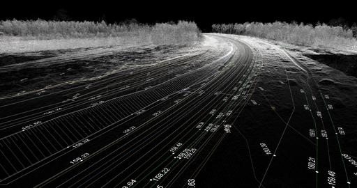
top of page

SERVICES

Topographical Stock image.jpeg

Topographical Surveys

A topographical survey provides a detailed and accurate representation of the natural and man-made features of a piece of land.
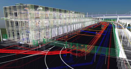
  Here are some key benefits of having a topographical survey:

​

  • Accurate Site Representation:  It captures precise details of the terrain, including elevation changes, contours, slopes, and existing features like buildings, trees, roads, and utilities. This information is crucial for architects, engineers, and designers to create accurate plans and designs for construction or development projects.

  • Planning and Design: Topographical surveys serve as a foundation for site planning and design. They help in determining the most suitable locations for buildings, infrastructure, drainage systems, and other elements by considering the existing landscape and its features.

  • Risk Assessment and Mitigation: Identification of potential risks, such as areas prone to flooding, steep slopes, or unstable ground, allows for informed decision-making to mitigate these risks during the planning phase.

  • Cost Savings: By having a comprehensive understanding of the site's characteristics, potential issues can be addressed in the design phase, reducing the likelihood of costly surprises or design changes during construction.

  • Legal and Planning Requirements: Many local authorities require topographical surveys as part of the planning permission process. Having a detailed survey that meets regulatory standards can streamline the approval process for construction projects.

  • Efficient Construction: Accurate topographical data enables contractors to plan construction activities more efficiently, reducing the need for extensive site investigations during the building phase and ensuring proper alignment with the landscape.

  • Environmental Considerations: Understanding the existing features of the land allows for environmentally sensitive planning, helping to preserve natural resources and protect ecological systems during development.


In essence, a topographical survey serves as a fundamental tool for informed decision-making, efficient design, and successful execution of construction or development projects while minimizing risks and maximizing cost-effectiveness.

Measured Building Surveys
AdobeStock_327641133.jpeg

Measured Building Surveys

Measured building surveys involve comprehensive assessments and documentation of a structure's dimensions, layout, and features.
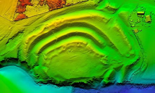
 These surveys employ a range of cutting-edge technologies, such as laser scanning, 3D modelling, and precise measurement tools, to create accurate representations of buildings. They provide architects, engineers, and construction professionals with crucial data for renovation, refurbishment, or new construction projects. The surveys capture intricate details like floor plans, elevations, and sections, ensuring an exhaustive understanding of the building's existing conditions. From heritage sites to modern structures, these surveys are instrumental in maintaining historical integrity, enhancing designs, and facilitating seamless construction processes. They serve as the cornerstone for informed decision-making, enabling stakeholders to optimize space, improve efficiency, and achieve architectural excellence.

Volmetric Surveys
Volumetric Survey.jpg

Volumetric Surveys

Volumetric surveys are crucial in various industries, especially in construction, mining, and land development, as they provide precise measurements of three-dimensional spaces. These surveys involve the calculation of volumes for a specific area, whether it's determining the quantity of material to be excavated for construction or assessing the stockpile inventory in mining operations. By utilizing advanced surveying techniques and technology like drones, LiDAR (Light Detection and Ranging), or GPS, these surveys offer accurate and detailed information about the terrain or structure being analysed.

Deformation Monitoring
AdobeStock_263859766.jpeg

Deformation Monitoring

Deformation or monitoring surveys, are conducted to measure and analyse changes in the shape or position of structures, terrain, or objects over time. The primary goal of deformation surveys is to detect and quantify movements, subsidence, or shifts in the monitored area, allowing for proactive measures to address potential risks or structural issues.


Using our advanced surveying instruments like total stations, GPS, and inclinometers we measure changes in elevation, angles, and distances with high precision. Continuous monitoring of key control points helps us to identify any deviations from the expected positions, allowing for prompt intervention in case of structural movement or settlement.

HD Laser Scanning
HD Laser Scanning.jpg

HD Laser Scanning

Using an extensive range of HD Laser Scanning technology to efficiently capture highly accurate and reliable data in Point Cloud format, we provide detailed data and information to aid the design process across projects.

​

Accurate Point Cloud Data can be imported to AutoDesk REVIT Architecture, AutoDesk REVIT Structure and AutoDesk REVIT MEP to create accurate data rich BIM compliant / ready 3D Models.


At Foresite Geomatics we provide comprehensive data capture and documentation services where 3D Point Cloud data can be accessed remotely through our 'shared' Point Cloud platform, providing instant access and rapid dimensional interrogation.

Utility Surveys
Utility Surveys.jpeg

Utility Surveys

Underground utility surveys are carried out using a combination of Electromagnetic Location (EML) and Ground Penetrating Radar (GPR) methods.  All utilities are physically marked / sprayed on the ground, the information is transferred onto a Topographical / Land Survey and delivered as a final drawing in AutoCAD format.

​

Underground utility surveys would be related to the Ornance Survey National Grid Reference System (OSGB36) and Ordnance Datum (AOD).

​

Survey data is post-processed in-house through the use of dedicated survey mapping software and rigorous QA / QC procedures to ensure we deliver consistent and reliable results, delivered in a variety of industry standard 2D and 3D formats.

Boundary Surveys

Boundary Surveys

Boundary surveys and land registry play crucial roles in defining and safeguarding property rights and boundaries. A boundary survey is a detailed examination and mapping of a property's physical boundaries. It involves measuring the land, identifying existing markers or monuments, and recording precise details about property lines, corners, and any encroachments or discrepancies.

​

This survey is instrumental in preventing disputes between neighbouring property owners and ensuring that landowners have a clear understanding of their property's limits.

Engineering services

Engineering Services

Our team of experienced geospatial engineering surveyors, integrated with the latest high-precision total stations and proven processes, allow us to deliver an efficient and cost-effective solution to your site control and setting-out requirements.

​

Foresite Geomatics can provide an initial site visit to establish / verify survey control and architectural design site grid systems.  We also provide options ranging from medium - long term site engineering resource, supervision, quality assurance and setting out, throughout a project's life cycle.

​

Our engineering services include:

  • Site Setout: Using high accuracy total stations we can transfer your CAD designs to the real world using established workflows, along with stringent checking procedures and QA.

  • Site Control: At Foresite Geomatics we have many years of experience establishing and transferring accurate site control on a wide range of construction sites and buildings.

  • As Built Surveys:  As built surveys can be produced for project records as the project advances.

  • Volume Surveys:  When required, we can produce stockpile volumes to assist with extraction quantities and earthworks.

  • Deformation Monitoring:  We can provide movement and crack monitoring for buildings or structures.  We monitor for any movement while construction progresses and produce detailed easy to read reports on the findings.

bottom of page